Types of geospatial and geotemporal data(地理空间与地理时间数据类型)
There are many types of geospatial and geotemporal data that you may work with in Foundry. It is important to understand what type of data you have when planning how to use it.
There are two main types of geospatial data: raster and vector. Geospatial data with a temporal component is known as geotemporal data.
All example images use notional or open-source data.
Raster data
Raster data consists of a matrix of cells organized into rows and columns, in which each cell represents specific information. Examples of raster data include satellite imagery sources, scanned maps, and digital elevation models (DEMs).
Learn more about processing raster data.

Vector data
Vector data is used for storing data that has discrete boundaries and represents these data as points, lines, and polygons. Examples of vector data include points representing cities on a map of the United States, lines representing roads in a state, and polygons representing electoral district boundaries.
Learn more about processing vector data in transforms.

Geotemporal data
Geospatial data may have a temporal component, such as the location of a vehicle over time or satellite images taken at different times. In these cases, the data is considered geotemporal (also referenced as "track" data). Learn more about geotemporal data in Foundry by reviewing the key concepts below.
Key geotemporal data concepts
:::callout{theme="neutral"}
The concepts defined below cite the implementation of Palantir's geotemporal interfaces available for installation as part of the Core Ontology Store in Marketplace.
Contact Palantir Support if these interfaces are not available on your enrollment, or if you have questions about Marketplace installation or are unable to locate the Core Ontology Store.
:::
Geotemporal activity
A geotemporal activity is an ontology object that:
- References a specific geotemporal series sync through a geotemporal series reference property.
- Represents individual observations through its implementation of the
Geotemporal Observationinterface. TheGeotemporal Observationinterface defines an observation as a timestamped position that encodes geotemporal data from varying sources. - Links to clusters, or collections of geotemporal data of the same type, of observations through its implementation of the
Geotemporal Clusterinterface. TheGeotemporal Clusterinterface contains the geotemporal data of the cluster's latest observation.
Geotemporal series
A geotemporal series is a sequence of position and timestamp data representing the location of an entity over time. Each sequence is identified by a series ID. Individual points in the series are referred to as observations. For example, a flight from San Francisco to New York City could be represented as a geotemporal series where each reported location from the plane during the flight is an observation.
:::note{theme="neutral"} Geotemporal series may also be referred to as geotime series. :::
Learn more about geotemporal series data.
Geotemporal series object type
A geotemporal series object type contains one or more geotemporal series reference properties, and optionally, other properties about the geotemporal series being referenced. For example, an object type representing a flight may include the origin and destination airports as string properties along with the flight path as a geotemporal series reference. A geotemporal series activity object references a geotemporal series sync.
Other variations of object types that drive geotemporal workflows include the following:
-
Geotemporal observation activity: An object that contains latitude, longitude, and timestamp properties and represents a point-in-time observation as opposed to a track. These objects implement the
Geotemporal Observationinterface. -
Geotemporal cluster activity: An object that links to multiple geotemporal observation activity objects and contains
timestampandgeopointproperties, which represent the time and position of the latest observation linked to the cluster. These objects implement theGeotemporal Clusterinterface.
Geotemporal series reference (GTSR)
A geotemporal series reference (GTSR) property type is used to reference a particular geotemporal series from a geotemporal series integration. Foundry applications use this reference to fetch the backing geotemporal data for the series.
Geotemporal series sync (GTSS)
A geotemporal series sync (GTSS) indexes the geotemporal series data into Foundry's geotemporal series database. Once indexed, the geotemporal data is accessible from the GTSR property on an object type. All values for a series ID should be contained in the same sync. The sync can be created using the geotemporal series sync output in Pipeline Builder, which enables you to write a GTSS to Foundry's live or historical geotemporal series databases as well as render it as a layer on a Gaia map.
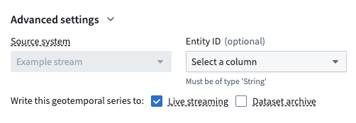
Live streaming enables real time GTSS rendering and is best for high-frequency streams that require low latency, storing observations for 14 days by default. Dataset archive provides persistent storage of high volumes of historic GTSS data within a dataset.
Geotracker
Geotracker is an entity-tracking capability supported by the Ontology, where an entity's location is derived from one or multiple linked object types.
Geotrackable entity
An object type representing an entity, such as a car or plane, is geotrackable when:
- Its current and historical locations derive from linked objects that contain data about its activities, or a series of one or more timestamped positions that encode geotemporal data from one or multiple sources, such as an airplane's movement over time. This data is often captured by a GTSR property.
- It implements the
Tracked Entityinterface.
Observation
An observation is an individual point in a geotemporal series that consists of a series ID, timestamp, position, and other integration-defined properties. For example, a single GPS ping from a plane would be an observation in a geotemporal series. These can also be called "ticks".
Series ID
A series ID is an identifier that groups multiple geotemporal observations into a single series. The series ID must be unique within a given geotemporal series integration. For example, the concatenation of the flight number, origin, destination, and date could be used to uniquely identify a single flight.
中文翻译
地理空间与地理时间数据类型
在 Foundry 中,您可能会处理多种类型的地理空间(geospatial)和地理时间(geotemporal)数据。在规划如何使用数据时,理解所拥有的数据类型至关重要。
地理空间数据主要分为两类:栅格数据 和 矢量数据。包含时间维度的地理空间数据称为 地理时间数据。
所有示例图片均使用概念性或开源数据。
栅格数据 (Raster data)
栅格数据由按行和列组织的单元格矩阵构成,每个单元格代表特定信息。栅格数据的示例包括卫星影像源、扫描地图和数字高程模型(DEM)。
了解更多关于处理栅格数据的信息。
矢量数据 (Vector data)
矢量数据用于存储具有离散边界的数据,并以点、线和面形式呈现。矢量数据的示例包括:代表美国地图上城市的点、代表某州道路的线,以及代表选区边界的面。
了解更多关于在转换中处理矢量数据的信息。
地理时间数据 (Geotemporal data)
地理空间数据可能包含时间维度,例如车辆随时间变化的位置或不同时间拍摄的卫星图像。在这种情况下,数据被视为地理时间数据(也称为"轨迹"数据)。通过查看以下关键概念,了解 Foundry 中的地理时间数据。
地理时间数据关键概念
:::callout{theme="neutral"}
以下定义的概念引用了 Palantir 地理时间接口的实现,这些接口可作为 Marketplace 中 Core Ontology Store 的一部分进行安装。
如果您的注册环境中没有这些接口,或对 Marketplace 安装有疑问,或无法找到 Core Ontology Store,请联系 Palantir 支持团队。
:::
地理时间活动 (Geotemporal activity)
地理时间活动是一种本体对象(ontology object),它:
- 通过地理时间序列引用属性引用特定的地理时间序列同步。
- 通过实现
Geotemporal Observation接口来表示单个观测值。Geotemporal Observation接口将观测值定义为带有时间戳的位置,该位置编码了来自不同来源的地理时间数据。 - 通过实现
Geotemporal Cluster接口,链接到观测值的聚类(clusters),即同一类型地理时间数据的集合。Geotemporal Cluster接口包含该聚类最新观测值的地理时间数据。
地理时间序列 (Geotemporal series)
地理时间序列是一系列位置和时间戳数据,表示实体随时间变化的位置。每个序列由序列 ID 标识。序列中的单个点称为观测值。例如,从旧金山到纽约市的航班可以表示为一个地理时间序列,其中飞机在飞行过程中报告的每个位置都是一个观测值。
:::note{theme="neutral"} 地理时间序列也可称为 geotime series。 :::
地理时间序列对象类型 (Geotemporal series object type)
地理时间序列对象类型包含一个或多个地理时间序列引用属性,以及可选的其他关于被引用地理时间序列的属性。例如,表示航班的对象类型可能包含出发地和目的地机场作为字符串属性,以及飞行路径作为地理时间序列引用。地理时间序列活动对象引用地理时间序列同步。
驱动地理时间工作流的其他对象类型变体包括:
-
地理时间观测活动 (Geotemporal observation activity): 包含纬度、经度和时间戳属性的对象,表示某个时间点的观测值,而非轨迹。这些对象实现
Geotemporal Observation接口。 -
地理时间聚类活动 (Geotemporal cluster activity): 链接到多个地理时间观测活动对象的对象,包含
timestamp和geopoint属性,这些属性表示链接到该聚类的最新观测值的时间和位置。这些对象实现Geotemporal Cluster接口。
地理时间序列引用 (Geotemporal series reference, GTSR)
地理时间序列引用(GTSR)属性类型用于从地理时间序列集成中引用特定的地理时间序列。Foundry 应用程序使用此引用来获取该序列的底层地理时间数据。
地理时间序列同步 (Geotemporal series sync, GTSS)
地理时间序列同步(GTSS)将地理时间序列数据索引到 Foundry 的地理时间序列数据库中。索引后,地理时间数据可通过对象类型上的 GTSR 属性访问。同一序列 ID 的所有值应包含在同一同步中。可以使用 Pipeline Builder 中的地理时间序列同步输出来创建同步,该输出允许您将 GTSS 写入 Foundry 的实时或历史地理时间序列数据库,并将其作为图层渲染在 Gaia 地图上。
实时流 (Live streaming) 支持实时 GTSS 渲染,最适合需要低延迟的高频流,默认存储 14 天的观测值。数据集存档 (Dataset archive) 提供对大量历史 GTSS 数据在数据集中的持久存储。
Geotracker
Geotracker 是一种由 Ontology 支持的实体追踪功能,实体的位置源自一个或多个链接的对象类型。
可地理追踪实体 (Geotrackable entity)
表示实体(如汽车或飞机)的对象类型在以下情况下被视为可地理追踪:
- 其当前和历史位置源自包含其活动数据的链接对象,或一系列一个或多个带时间戳的位置,这些位置编码了来自一个或多个来源的地理时间数据,例如飞机随时间变化的运动。此数据通常通过 GTSR 属性捕获。
- 它实现了
Tracked Entity接口。
观测值 (Observation)
观测值是地理时间序列中的单个点,由序列 ID、时间戳、位置和其他集成定义的属性组成。例如,飞机发出的单个 GPS 信号就是地理时间序列中的一个观测值。这些也可称为"ticks"。
序列 ID (Series ID)
序列 ID 是将多个地理时间观测值分组为单个序列的标识符。在给定的地理时间序列集成中,序列 ID 必须唯一。例如,航班号、出发地、目的地和日期的组合可用于唯一标识单个航班。